Happy New Year / End of this Blog

Just to make it official, I am writing this small article to state that this blog has come to an end. I kept it alive hoping that I would do something with it but I think my interest has shifted. I created this blog to uncover my neighbourhood’s name and “heart” and I feel like I’ve done that on the basic level I was looking for. As for my history research, I never quite had enough time to do any proper research with work and family life keeping me busy. Anyhow, I’ll keep the posts up nonetheless in case anybody ever wonders about our neighbourhood and wants some information to get them started. I am very grateful for all the people I’ve met because of this blog and the community doors this has opened. It makes me realise I need to do something completely new once again. Godspeed.

The Silent Ghosts of Hochelaga Yards

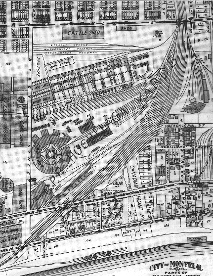
Hochelaga Yards circa 1907, Atlas Pinsonneault

Hochelaga Yards circa 1907, Atlas Pinsonneault

With a crescent moon at my back, I decided that tonight’s dog walk would lead me to nowhere in the very south-east portion of Hochelaga.  The map above and a book I just took out of the library was the motivation for tonight’s dogwalk.  The book is titled “Du chemin du Roy à la rue Notre-Dame” which at first & second glance potentially appears to have some answers for me as to how Sainte-Marie grew eastwards into once-Hochelaga territory (i.e. the land between the Canadian Pacific Railway and Iberville).  The book takes a look at the growth along Notre-Dame St. over the years so it starts with early “Quebec Suburbs” (Faubourg Québec) history and moves out towards Maisonneuve and Mercier.

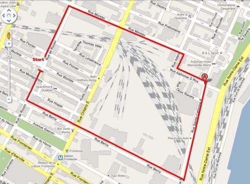
 I destined my walk towards what the book mentions as the Anglophone portion of Hochelaga (likely prior to the creation of the CPR lines in the 1870s) on a once-named “Marlborough St. » (today Alphonse D. Roy) and walked all the way around “Hochelaga Yards”. I started by heading down to De Rouen passed through the viaduct, down Moreau St. and turned right on Adam St. and found my way to old Marlborough St.  I found nothing but 60 or 70s built industrial company boxes, parked cars and fences but not one piece of history.  It was actually sad.  I continued south to St.Catherine to find myself in the middle of nowhere. Nothing spookey, no dark alleys.  Just well lit industrial nothingness and the crescent moon up high. I headed over the bridge that takes us over the most southern part of the CPR yards, and there I could see pretty much everything… the industrial part of Hochelaga, Longueil condo high-rises, La Ronde, les Tours Frontenac, downtown Montreal, Olympic Stadium and of course Hochelaga Yards itself (there’s a forest now where the Car Shop is placed in the 1907 map).  I headed back home up Bercy St. and just thought about how much has been lost to expropriation.  This is a large part of Montreal that has simply vanished and although I would consider it a wasteland, I was surprised to see how busy it was with night shift trucks and workers going in and out of the lots. I have never walked here at night so I had really no idea.

Time to start reading and touch base soon enough with my findings. Although I’m now wondering why they never named this area Hochelaga Yards as its kind of catchy and less confusing (i.e. is it Centre-Sud, Sainte-Marie or part of Hochelaga?)

Google Map of Hochelaga Yards/walk path

Google Map of Hochelaga Yards/walk path

New Blogs Coming on Centresud-Montreal.com

Recently I announced on Twitter that I would be transferring my neighbourhood blogs onto Centresud-Montreal.com which is a new community portal currently run by 4 residents.  It will be a challenge for me to write in French but I am welcoming this change.  Two blogs are in the works for this week – one to talk about a recent closing ceremony to thank all the park-committee volunteers from this past summer and the other will be of interest to those following my historical research.  I was lucky enough recently to meet more people from the Polish community in Sainte-Marie and was invited to their Harvest dinner, this opened up great conversations that I will have delve into deeper in the future but for now I’ll give you a bit of introduction (en français) to this community and their history in Sainte-Marie.  Stay tuned on Centresud-Montreal.com this week.  p.s. I am keeping this blog and with the separate website now in the works, I’ll let this blog evolve organically (probably my English writing mixed in with more personal blogs – basically talking about my family activies + my research when the work itself is not ready to be published).

St-Eusèbe ward research (first hint?)

Just spent an hour going through Google archives to see if I could get back into one of my next historical goals which was to track the history of how early Montreal 19th century neighbourhood history (parishes & « côtes » – see my pre-1840 early Montreal history series for more details) transformed into a more formal municipal ward system.  Additionally, I want to see when the Hochelega ward that started at Iberville officially changed lines to the CP rail tracks which ultimatley made way to the St-Eusèbe ward.  Never really found any books or maps to showcase Montreal wards to see at what period this happened so more research will be necessary.  Google searches provide election details of the St-Eusèbe ward starting in the 30s but I found this link to a 1903 story that is actually about  a St-Jean-Baptiste celebration which talks about how the festival procession leads to Cathedrals in different « divisions » (neighbourhoods?) made up of different « societies » (wards in the making?).  St-Eusèbe and other societies like Hochelaga, Notre-Dame-de-Grace and Villeray are mentioned here.  What I find interesting (and maybe I’m reading way too much between the lines) is that there seems to be a transition hint here from Parish-neighbourhoods to Ward-neighbourhoods.  On one hand, the French-Canadian catholic festival leads to cathedrals but involves more modern 20th century municipal divisions.  Anyhow, maybe this is a hint of the parish-to-ward change or maybe not.  Click here for the link to see for yourself.

Anyhow, definitely would like to pursue this research further when time will allow.  How did we go from parishes to wards?  What books are out there that could help find this information?  I fear this is not a simpler library textbook research.

Souper Solidarité pour Styl’Afrique Coop

Bonjour tout le monde, voici un message de l’équipe Styl’Afrique Coop. J’encourage les résidents à participer et de se rejoindre ensemble demain pour une bonne cause locale. n.b. ce souper aura une option végé/ Hello everyone, here’s a message from the Styl’Afrique Coop. I encourage all residents to participate and to get together for a good local cause. p.s. this dinner will have a vegetarian option.

RAPPEL IMPORTANT

Invitation à notre souper solidarité!
Pour faire suite à notre article sur l’acte de vandalisme commis chez Styl’Afrique coop, nous souhaitons vous inviter à prendre part à notre souper solidarité qui vise à réunir les fonds pour réparer notre vitrine détruite.

Venez vous régaler avec nous et contribuer ainsi à la cause de Styl’Afrique Coop! Aussi, prenons le temps de prendre des nouvelles de tout le monde…

Quand? vendredi le 1er octobre 2010 , 18h00

Où? Centre Jean-Claude Malépart, 2633, rue Ontario Est (Métro Frontenac)


Coût: 10$ souper spaghetti, 15$ souper africain.

Il y aura aussi vente d’objets d’arts et de vêtements africains sur place.
Pour plus d’informations, communiquez avec nous au: (514) 509-7528

Amenez vos amis et connaissances, une belle façon de terminer la semaine
en bonne compagnie…

Au plaisir de vous y voir nombreux!

L’équipe de Styl’Afrique Coop
http://www.stylafriquecoop.com